Mountaineering - General Conditions
Latest Condition Images (x30)
Click Here to search the entire condition image gallery
-
20/07/2026
 - Crow Face
Viewed from upper Rome Ridge approach
by Viv Luciani")
Mt Rolleston (2275m) - Crow Face -
20/07/2026
 - Goldney Ridge
Viewed from upper Otira Slide
by Viv Luciani")
Mt Rolleston (2275m) - Goldney Ridge -
20/07/2026
 - High Peak Access
Viewed from Low Peak
by Viv Luciani")
Mt Rolleston (2275m) - High Peak Access -
20/07/2026
 - Rome Ridge (lower approach)
Viewed from below 2nd buttress
by Viv Luciani")
Mt Rolleston (2275m) - Rome Ridge (lower approach) -
20/07/2026
 - Rome Ridge (upper arete)
Upper ridge viewed from above Gap climb
by Viv Luciani")
Mt Rolleston (2275m) - Rome Ridge (upper arete) -
16/07/2026
 - North Aspect
Viewed from Arthur's Pass (920m)
by Graeme Kates")
Avalanche Peak (1833m) - North Aspect -
16/07/2026
 - Head of Jordan Stream
Viewed from Klondyke Corner
by Graeme Kates")
Black Range (1800m) - Head of Jordan Stream -
16/07/2026
 - West aspect
Viewed from Arthur's Pass (920m)
by Graeme Kates")
Blimit (1921m) - West aspect -
16/07/2026
 - West aspect
Viewed from Bruce Stream
by Graeme Kates")
Brown Hill (1716m) - West aspect -
16/07/2026
 - East aspect
Viewed from Arthur's Pass Village
by Graeme Kates")
Lyell Peak (1828m) - East aspect -
16/07/2026
 - North aspect
Viewed from Greyneys Creek
by Graeme Kates")
Mid Hill (1831m) - North aspect -
16/07/2026
 - North aspect
Viewed from Arthur's Pass (920m)
by Graeme Kates")
Mt Bealey (1836m) - North aspect -
16/07/2026
 - West aspect
Viewed from Klondyke Corner
by Graeme Kates")
Mt Binser (1860m) - West aspect -
16/07/2026
 - North aspect
Viewed from Greyneys Creek
by Graeme Kates")
Mt Bruce (1630m) - North aspect -
16/07/2026
 - East aspect
Viewed from Klondyke Corner
by Graeme Kates")
Mt Davie (2280m) - East aspect -
16/07/2026
 - East aspect
Viewed from Klondyke Corner
by Graeme Kates")
Mt Harper (2222m) - East aspect -
16/07/2026
 - South aspect
Viewed from Greyneys Creek
by Graeme Kates")
Mt Oates (2041m) - South aspect -
16/07/2026
 - Bealey Face
Viewed from Arthur's Pass (920m)
by Graeme Kates")
Mt Rolleston (2275m) - Bealey Face -
16/07/2026
 - Rome Ridge (Northeast aspect)
Viewed from Arthur's Pass (920m)
by Graeme Kates")
Mt Rolleston (2275m) - Rome Ridge (Northeast aspect) -
16/07/2026
 - Southeast aspect
Viewed from Klondyke Corner
by Graeme Kates")
Mt Stewart (1934m) - Southeast aspect -
16/07/2026
 - West aspect
Viewed from Arthur's Pass (920m)
by Graeme Kates")
Mt Temple (1913m) - West aspect -
16/07/2026
 - South Face
Viewed from Arthur's Pass (920m)
by Graeme Kates")
Phipps Peak (1965m) - South Face -
16/07/2026
 - Southwest aspect
Viewed from Klondyke Corner
by Graeme Kates")
The Dome (1938m) - Southwest aspect -
16/07/2026
 - Southwest aspect
Viewed from Bealey/Mingha confluence
by Graeme Kates")
The Spike (1440m) - Southwest aspect -
12/07/2026
 - Upper Avalanche Peak track
Viewed from Scott's track looking south
by Graeme Kates")
Avalanche Peak (1833m) - Upper Avalanche Peak track -
12/07/2026
 - Upper Scott's track
Viewed from upper Scott's track
by Graeme Kates")
Avalanche Peak (1833m) - Upper Scott's track -
12/07/2026
 - West Ridge
Viewed from Avalanche Peak (Scott's track)
by Graeme Kates")
Mt Aicken (1858m) - West Ridge -
12/07/2026
 - West aspect
Viewed from Avalanche Peak (Scott's track)
by Graeme Kates")
Mt O'Malley (1703m) - West aspect -
04/05/2026
 - East aspect
Viewed from Mt Stuart approach
by Viv Luciani")
Hills Peak (1640m) - East aspect -
04/05/2026
 - West aspect
Viewed from Mt Stuart
by Viv Luciani")
Mt Franklin (2145m) - West aspect
Storm & Snow Models
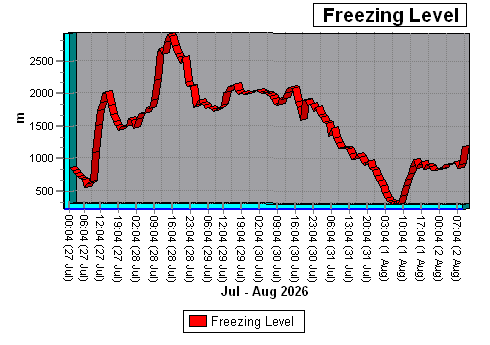
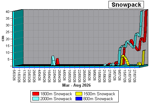
SNOW MODELLast Update: 2/08/2026 09:04 NZST
Location: Mt Rolleston (Goldney Ridge) 1800m
Alt. Temp: -2.6ºC
Freezing Level: 1201m
Lapse Rate: -0.431ºC/+100m
Alt. Humidity: 93%
Alt. Windspeed: 21.7kmph
Alt. Av. Windspeed: 18.8kmph
Alt. Min. Windspeed: 11.4kmph
Alt. Max. Windspeed: 27.7kmph
Alt. Wind Chill: -8.8ºC
Alt. Air Pressure: 815hPa
Alt. 3 Day Rainfall: 34.9mm (Today: 0.0mm)
Last Snowfall: 1 days ago
7 Day Snowfall: 24.8cm
Snowpack Depth: 40.2cm
Windslab E: 42.8cm
Surface Stability (@ 35º): Very Poor (Warning: Slab present!)
Avalanche Chance: 50%
Avalanche Risk
Avalanche Size Chart(MSC Assessment)
Snow Model Graphs
Click Here to view full snow model details.